
Andebit et beaqui corendit, ut quostes esciendion re dit ad et prae parion es quia quas alibus sam, omnim faciden ducipidiat arum autem nobis enis es voat

21. Driving Switchback and Cheney Roads
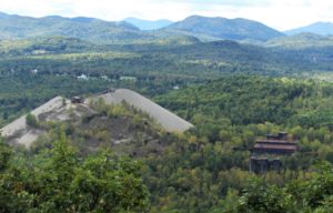
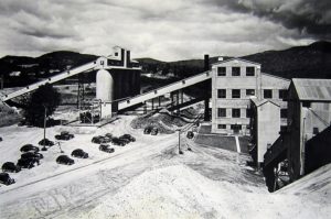
Republic Steel and the #7 Sintering Plant
Audio Narration of the Iron Story Site 21
From Grover Hills, down to Port Henry, the street names call out details of the local iron industry. Switchback refers to the track improvement that replaced the original three “Ys” that enabled the Lake Champlain and Moriah Railroad to climb nearly 1,400 feet from the shore of Lake Champlain to Mineville, in 1869. Pumphouse Lane, leading to the water treatment facility, recalls the days when the pumps ran constantly to remove water from the mines; this water supplied the town’s water needs then and now. Forge Hollow Road refers to the iron forge located at a hollow of Mill Brook.
The operations of Republic Steel focused on the production of concentrate or sintered ore, which could go directly into the company’s blast furnaces at more distant locations. So while furnace operations were not in the interests of Republic Steel, the development of more extensive sintering facilities were. One important factor in picking a concentrating site was water. So-called wet mills diminished the incidence of silicosis among the workers. Republic Steel chose a site on the railroad line between Mineville and Port Henry where water could be acquired from Bartlett Pond Brook. The plant was built in 1943 with a capacity of 300 tons of finished product per hour. Construction was funded by the US federal government—underlining the importance of steady iron supplies during World War II. Ore was transported by railroad, concentrated, then taken by rail to be shipped to Republic’s plants in western New York and other locations.
This drive loops around the #7 tailings pile, which looms over the landscape. Dramatic glimpses of it can be had from the south end of Forge Hollow Road and several spots on North Mill Road. After Grover Hills, turn right on North Mill Road. Stay on it until it becomes Switchback Road. Then turn left at Cheney Road, which will take you back onto Pilfershire Road. Turn right when you reach the intersection with Pilfershire Road.
Travel Tools
The trailhead for Cheney Mountain Trail is on the south side of Pilfershire Rd 1.4 mi west of Rt 22/9N. Walk around the fenced gate and hike up a logging road. The trail narrows on the climb to the summit. At the top, you will pass a number of small wetlands. There are three viewpoints: north up the lake, west toward the High Peaks, and south to Lake Champlain and Champlain Bridge. The trail is 1.5 mi RT.