
Andebit et beaqui corendit, ut quostes esciendion re dit ad et prae parion es quia quas alibus sam, omnim faciden ducipidiat arum autem nobis enis es voat

9. Driving South of Essex: Burgoyne’s Long Flotilla
A huge line of soldiers, ships, supplies, and support teams made their way south on the lake. The lead group would set up camp in the wild woods along the lake.
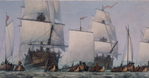
Burgoyne’s flotilla extended in a long line as they preceded south on Lake Champlain. The first group of the army under Brigadier General Fraser would go ashore to clear a place to camp, which would then also serve as a campground for the next group. Each evening, the soldiers and camp followers would disembark and get to work setting up camp.
Here in the wilderness, the soldiers were at a disadvantage. The surrounding forest and steep cliffs offered places where the Rebels could shoot and hide. There were no raids against the army, but the threat was present and palpable. The men needed to be prepared at a moment’s notice.
The men not only needed to be prepared to fight but prepared for the wilderness. Snakes, bugs, and other pests were a constant nuisance, creating a physical and psychological challenge for the soldiers. As the cool spring departed, the summer heat brought out black flies, mosquitoes, gnats, and other annoyances.
This area is known as Split Rock, one of the places where Burgoyne’s men camped. If you are on the lake, you would see a split in the granite rock that creates a little island off the point. This rock was known to the Abenaki as “the rock split through.” Indians used distinctive landmarks, such as Split Rock, to define a nation’s territory. It is widely believed that Split Rock was the border between the Algonquians in the north and the Iroquois to the south before the Europeans carved out their own borders.
Travel Tools
Start track 9 once you approach Whallons Bay, just south of the hamlet of Essex. During this part of the journey on the Turning Point Trail, you will drive by the 3,700-acre Split Rock Wild Forest, between the towns of Essex and Westport. The forest is part of the Adirondack Forest Preserve. Located in the eastern foothills of the Adirondack Mountains along the shore of Lake Champlain, it comprises the largest tract of undeveloped Lake Champlain shoreline in New York.
The trailhead is on Lakeshore Road, 5.8 miles south of Essex and 4.7 miles north of Westport. Trails go up, over, and along this mountain overlooking Lake Champlain with wetlands, little waterfalls, an old quarry, hidden bays, and views. The trails range from 2- to 6-mile loops, easy to moderate.
The wild forest is named for Split Rock Mountain, the main feature of the area. The Lake Champlain Palisades and Webb Royce Swamp are within its boundaries. The trail system provides many scenic views of Lake Champlain and the Green Mountains of Vermont. The Westport Boat Launch Site, located in the Hammond Pond Wild Forest, is the nearest location to launch on the lake and access the shoreline campsites on Split Rock Wild Forest.
CLICK TO VIEW SITE TEN
First-Hand Accounts
Visualizing General Burgoyne’s Army on Lake Champlain:
“His [General Burgoyne’s] whole army appeared in perfect regularity as to form the most complete and splendid regatta you can possibly conceive. It was a majestic sight, with the Indians in their birch canoes holding between twenty and thirty men each, followed by the gunboats, together with brigs and sloops.” –Historian Nicholas Westbrook