Andebit et beaqui corendit, ut quostes esciendion re dit ad et prae parion es quia quas alibus sam, omnim faciden ducipidiat arum autem nobis enis es voat

Blueway Trail: Monitor Bay to Ticonderoga

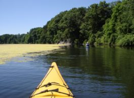
This segment explores a narrow and marshy section of the lake. Wildlife is abundant here, especially birds and waterfowl. Here, the lake becomes quite narrow and feels almost river-like. This segment travels the same waters as countless ships have in the long history of Lake Champlain.
Launch Sites: Monitor Bay Park and Marina; Ticonderoga NYS Boat Launch
Paddling Distance: 7.7 Miles (12.4 kilometers)
Notes: North and south winds can result in choppy water, but generally this segment is protected. Limited shore access. Milfoil can make paddling more challenging.
Activities: 0 hours
Driving: 23 min/13.1 mi
Duration: 1 day
Start at Monitor Bay Marina
Go northwest toward Ferry Rd
0.10 mi – 00:00:29
Turn left on Ferry Rd
0.22 mi – 00:00:31
Turn left on Station St
0.23 mi – 00:00:33
Bear left on RT-22 (RT-9N)
3.01 mi – 00:03:48
Turn left on Sawyer Rd
0.30 mi – 00:00:43
Make sharp left on Shore-Airport Rd (CR-43)
0.79 mi – 00:01:07
Turn left on Lester Hack Rd
0.09 mi – 00:00:12
Turn left on Terminal Rd
0.54 mi – 00:01:18
Continue on Jackson Way
0.05 mi – 00:00:07
Arrive at Kempton’s Cove, on the right
Depart Kempton’s Cove
Go back west on Jackson Way
0.05 mi – 00:00:07
Continue on Terminal Rd
0.54 mi – 00:01:18
Turn right on Lester Hack Rd
0.09 mi – 00:00:12
Make sharp left on Shore-Airport Rd (CR-43)
1.89 mi – 00:02:15
Make sharp left on Kirby Pt
0.88 mi – 00:02:07
Arrive at Kirby Point, on the left
Depart Kirby Point
Go back west on Kirby Pt
0.88 mi – 00:02:07
Turn left on Shore-Airport Rd (CR-43)
1.42 mi – 00:01:53
Make sharp left on RT-74 (RT-22)
0.51 mi – 00:00:44
Turn left at RT-22 / Montcalm St to stay on RT-74 (Fort TI Rd)
1.47 mi – 00:03:29
Take Fort Ticonderoga-Larrabees Point Fry ferry
00:00:00
Arrive at Cable Ferry (Fort Ticonderoga Ferry), on the right
Depart Cable Ferry (Fort Ticonderoga Ferry)
Go back west on Fort Ticonderoga-Larrabees Point Fry
00:00:00
Go on RT-74 (Fort TI Rd)
0.03 mi – 00:00:10
Finish at Ticonderoga NYS Boat Launch, on the left