Andebit et beaqui corendit, ut quostes esciendion re dit ad et prae parion es quia quas alibus sam, omnim faciden ducipidiat arum autem nobis enis es voat

Blueway Trail: Port Kent to Cumberland Bay
It is recommended that this route be completed south to north. This route begins in the now-quiet-but-once-bustling town of Port Kent and continues north to two different wildlife management areas, both of which offer excellent wetland and wildlife viewing opportunities. This trail also passes the sites of both the Battle of Valcour and the Battle of Plattsburgh, leading paddlers through the same waters and channels that soldiers of various nationalities fought for control over almost 200 years ago. The route ends at the Plattsburgh City Beach, which is adjacent to Cumberland Bay State Park.
Launch Sites: Plattsburgh City Beach; Port Kent Ferry Landing
Approximate Paddling Distance: 16 miles (25.7 kilometers)
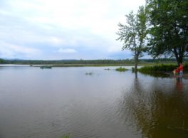
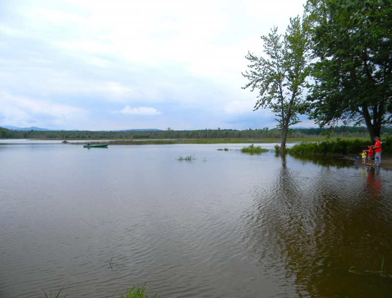
Insider Tip from Paddlers Cathy Frank and Margaret Holden: “Make sure you give yourself time to check out Ausable Marsh, home to an abundance of wildlife, including black duck, great blue heron, osprey, beaver, muskrat, turtles, fish, and frogs. The Ausable Marsh Walking Trail, about 1 mile, is a good way to explore. Because the area is rich in waterfowl, you may want to avoid paddling here during hunting season, as hunting is permitted. Paddling up the lower mouth of the Ausable River and around to the upper mouth is a beautiful protected paddle.”
Other Notes: This segment is exposed to strong north and south winds and waves.
Activities: 0 hours
Driving: 56 min/21.8 mi
Duration: 1 day
Start at Port Kent Ferry Landing
Go southwest on RT-373
0.09 mi – 00:00:13
Arrive at Port Kent, on the right
Depart Port Kent
Go back north on RT-373
0.05 mi – 00:00:07
Arrive at Port Kent Beach, on the left
Depart Port Kent Beach
Go back south on RT-373
0.21 mi – 00:00:29
Turn right on Lake St
1.08 mi – 00:02:36
Arrive at Wickham Marsh Wildlife Management Area, on the left
Depart Wickham Marsh Wildlife Management Area
Continue northwest on Lake St
0.34 mi – 00:00:49
Continue on Giddings Rd
0.25 mi – 00:00:18
Turn right on Lakeside Rd
0.02 mi – 00:00:03
Bear left on Plains Rd
1.20 mi – 00:02:53
Turn right on Sunlea Village Dr
0.19 mi – 00:00:27
Turn right on US-9 (Lakes To Locks Psge)
2.24 mi – 00:02:34
Turn right on Ausable Point Rd
1.17 mi – 00:05:38
Arrive at Ausable Marsh Wildlife Management Area, on the right
Depart Ausable Marsh Wildlife Management Area
Go back west on Ausable Point Rd
0.32 mi – 00:01:32
Arrive at Ausable Point State Park, on the right
Depart Ausable Point State Park
Continue northwest on Ausable Point Rd
0.85 mi – 00:04:05
Make sharp right on US-9 (Lakes To Locks Psge)
2.20 mi – 00:02:37
Turn right on Santa Ln
0.18 mi – 00:00:25
Turn right on Coastland Dr
0.10 mi – 00:00:14
Arrive at Battle of Valcour Site, on the left
Depart Battle of Valcour Site
Go back north on Coastland Dr
0.10 mi – 00:00:14
Turn left on Santa Ln
0.18 mi – 00:00:25
Turn right on US-9 (Lakes To Locks Psge)
2.84 mi – 00:04:13
Turn right on Clifton Point Dr (Clinton Point Dr)
00:00:01
Arrive at Hotel Champlain (now Clinton Community College), on the left
Depart Hotel Champlain (now Clinton Community College)
Go back west on Clifton Point Dr (Clinton Point Dr)
00:00:01
Turn right on US-9 (Lakes To Locks Psge)
2.18 mi – 00:03:49
At roundabout, take the first exit to proceed on New York Rd
0.13 mi – 00:00:29
Turn left on Ohio Ave
0.08 mi – 00:00:19
Make sharp right on US Oval
0.41 mi – 00:01:38
Continue on President TR Ln (President T Roosevelt Ln)
0.11 mi – 00:00:18
Continue on Club Rd
0.26 mi – 00:00:56
Turn left on Hamilton St
0.06 mi – 00:00:16
Turn right on Macdonough St
0.15 mi – 00:00:55
Turn right on Bridge St and immediately turn left on Dock St
0.18 mi – 00:00:47
Bear left to stay on Dock St
0.05 mi – 00:00:31
Arrive at Plattsburgh Breakwater, on the right
Depart Plattsburgh Breakwater
Go back west on Dock St
0.21 mi – 00:01:22
Turn right on Bridge St
0.32 mi – 00:01:26
Turn right on City Hall Pl (US-9 N)
0.22 mi – 00:00:44
Continue on Cumberland Ave (Lakes To Locks Psge)
0.02 mi – 00:00:02
Arrive at Saranac River, on the right
Depart Saranac River
Go back west on Cumberland Ave (Lakes To Locks Psge)
0.02 mi – 00:00:02
Turn right on Sailly Ave
0.63 mi – 00:02:32
Turn right on US-9 (Margaret St)
1.28 mi – 00:02:40
Turn right on Cumberland Head Rd (RT-314 E)
0.24 mi – 00:00:30
Turn right on Beach Rd
0.20 mi – 00:01:23
Arrive at Cumberland Bay Battle Site, on the right
Depart Cumberland Bay Battle Site
Go back northwest on Beach Rd
0.17 mi – 00:01:08
Turn left on Crete Center Rd
0.06 mi – 00:00:13
Turn left
0.10 mi – 00:00:59
Arrive at Plattsburgh City Beach, on the left
Depart Plattsburgh City Beach
Go back northeast
0.10 mi – 00:00:46
Turn right on Crete Center Rd
0.06 mi – 00:00:18
Turn left on Beach Rd and immediately turn right on Cumberland Head Rd
0.76 mi – 00:01:26
At fork keep right on Cumberland Head Rd (CR-42 S)
0.09 mi – 00:00:08
Make sharp right on Fire House Ln (Firehouse Ln)
0.04 mi – 00:00:05
Turn left to stay on Fire House Ln (Firehouse Ln)
0.10 mi – 00:00:14
Finish at Cumberland Bay State Park, on the right