Andebit et beaqui corendit, ut quostes esciendion re dit ad et prae parion es quia quas alibus sam, omnim faciden ducipidiat arum autem nobis enis es voat

Blueway Trail: Port Kent to Willsboro

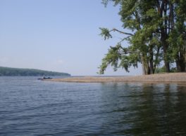
This route begins in the small community of Port Kent. The trail explores Schuyler Island, a site of boat-building history, and continues south to the historically commercial town of Port Douglas. Port Douglas offers paddlers the opportunity to stop and make use of a sandy beach and swimming area before continuing on to the deep and popular Willsboro Bay. Paddling down the west side of Willsboro Bay, cliffs and clefts tower along your right side.
Launch Sites: Port Kent Ferry Landing; Willsboro Bay NYS Boat Launch
Approximate Paddling Distance: 15 miles (24 kilometers)
Insider Tip by Paddlers Cathy Frank & Margaret Holden: “The undeveloped character of Schuyler Island, with primitive campsites, cobble beaches, and broad lake views, offers a peaceful place to relax or camp. A long spit of pebble beach on the west side of the island is a great spot to swim.”
Other Notes: When passing near Schuyler Island, watch the weather closely. Storms can appear suddenly due to a blocked westerly view where most storms come from. This segment is exposed to both north and south winds until Willsboro Bay is reached, which provides southern protection.
Activities: 0 hours
Driving: 55 min/29.2 mi
Duration: 1 day
Start at Port Kent Ferry Landing
Go southwest on RT-373 toward Lake St
0.60 mi – 00:01:27
Turn left on Trembleau Rd
1.71 mi – 00:04:07
Turn right on Water Edge Rd
0.42 mi – 00:01:00
Arrive at Schuyler Island, on the left
Depart Schuyler Island
Go back north on Water Edge Rd
0.42 mi – 00:01:00
Turn left on Trembleau Rd
1.71 mi – 00:04:07
Turn left on RT-373 (Route 373)
1.23 mi – 00:01:14
Bear left on Soper Rd (CR-17)
0.93 mi – 00:01:29
Turn left on Mace Chasm Rd (CR-71)
1.59 mi – 00:03:50
Turn left on Port Douglas Rd (CR-16)
2.10 mi – 00:03:51
Continue on Schuyler Rd
0.36 mi – 00:00:52
Turn left on Schuyler Rd and immediately turn right on Santor Dr
0.09 mi – 00:00:13
Arrive at Corlear Bay, on the right
Depart Corlear Bay
Go back west on Santor Dr
0.07 mi – 00:00:10
Turn left on Schuyler Rd and immediately turn right on Schuyler Rd
0.21 mi – 00:00:30
Arrive at Port Douglas, on the left
Depart Port Douglas
Continue south on Schuyler Rd
0.08 mi – 00:00:12
Arrive at Port Douglas Beach, on the left
Depart Port Douglas Beach
Go back north on Schuyler Rd
0.03 mi – 00:00:04
Arrive at Port Douglas NYS Boat Launch, on the right
Depart Port Douglas NYS Boat Launch
Go back south on Schuyler Rd
0.12 mi – 00:00:16
Continue on Port Douglas Rd (CR-16)
0.90 mi – 00:02:10
Make sharp left on Highlands Rd (CR-28)
7.47 mi – 00:14:22
Turn left on RT-22 (Lakes To Locks Psge)
3.93 mi – 00:05:25
Turn left on Farrell Rd (CR-27)
2.06 mi – 00:02:36
Turn left on Point Rd (CR-27)
0.54 mi – 00:00:50
Make sharp left on Marina Ln
0.91 mi – 00:02:12
Turn right on Ledge Ln
0.05 mi – 00:00:07
Arrive at Willsboro Bay, on the left
Depart Willsboro Bay
Go back south on Ledge Ln
0.05 mi – 00:00:07
Turn left on Marina Ln
0.91 mi – 00:02:12
Make sharp right on Point Rd (CR-27)
0.37 mi – 00:00:35
Turn right on Boat Launch Rd
0.34 mi – 00:00:49
Finish at Willsboro Bay State Boat Launch, on the left