Andebit et beaqui corendit, ut quostes esciendion re dit ad et prae parion es quia quas alibus sam, omnim faciden ducipidiat arum autem nobis enis es voat

Blueway Trail: Westport (Split Rock) to Essex

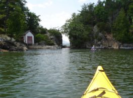
It is recommended that this segment be completed south to north. This segment explores the beginning of the section of the lake known as “The Narrows,” justly-named as it is the narrowest part of the lake. The trail takes paddlers through the many ins and outs of the harbors and points along this part of shoreline. Many of these spots have individual histories and stories. This route passes the renowned Palisades of Lake Champlain, a geological masterpiece of sheer cliffs ornamented with waterfalls and wildlife. Paddlers will also pass Split Rock, a historical landmark used to establish territory boundaries by Native Americans, and later by Europeans. This segment ends in the town of Essex, a popular summer tourist destination.
Launch Sites: Westport NY Boat Launch; Beggs Park
Insider Tip from Paddlers Cathy Frank & Margaret Holden: “Hands down, this is the most spectacular section of shoreline on Lake Champlain. Save it for a calm sunny day so you can stop and cherish each natural wonder. This is also the steep and deep part of Lake Champlain. The depth plunges from 200 feet near shore to 400 feet farther out. And the cliffs rise to 1,000 feet.”
Other Notes: This segment is best in calm weather. Do not attempt this segment if north/northwest or south/southwest winds are moderate to strong, or if storms are predicted. The narrow part of the lake near Split Rock funnels winds and waves to a higher pitch, and there is only limited shore access in case of emergency. The shoreline along this segment is the natural habitat of the timber rattlesnake, and its bite is a serious medical emergency although rarely fatal.
Bug spray is useful for this segment.
Activities: 0 hours
Driving: 3 hr, 6 min/93.1 mi
Paddling: 14.5 miles (23.3 kilometers)
Duration: 1 day
Start at Westport State Boat Launch
Go north on Champlain Ave (RT-22) toward Sherman Rd
0.09 mi – 00:00:09
Turn right on Lake Shore Rd (CR-80)
2.62 mi – 00:04:11
Turn right on Rock Harbor Way
2.40 mi – 00:05:48
Arrive at Rock Harbor, on the right
Depart Rock Harbor
Go back west on Rock Harbor Way
0.01 mi – 00:00:00
Arrive at Steam Mill Point, on the left
Depart Steam Mill Point
Go back east on Rock Harbor Way
0.01 mi – 00:00:00
Arrive at Barn Rock Harbor, on the left
Depart Barn Rock Harbor
Go back west on Rock Harbor Way
2.40 mi – 00:05:48
Make sharp right on Lakeshore Rd (CR-80)
4.97 mi – 00:06:51
Bear right to stay on Lakeshore Rd (CR-80)
2.61 mi – 00:04:48
Continue on Essex Rd (RT-22)
0.06 mi – 00:00:10
Turn right
0.08 mi – 00:00:51
Take Charlotte-Essex Fry ferry
2.77 mi – 00:16:42
Go on Ferry Rd (VT-F5)
0.48 mi – 00:02:08
Turn right at Wings Point Rd to stay on Ferry Rd (VT-F5)
2.35 mi – 00:05:30
Turn right on US-7 (Ethan Allen Hwy)
9.16 mi – 00:11:59
Turn right on VT-22A
1.78 mi – 00:04:16
Turn right on Panton Rd
1.38 mi – 00:02:31
Turn right on Basin Harbor Rd
4.71 mi – 00:07:34
Make sharp right on School House Rd (Schoolhouse Rd)
0.20 mi – 00:00:19
Turn left on Mile Point Rd
0.42 mi – 00:00:41
Turn left at Obryan Ln to stay on Mile Point Rd
0.21 mi – 00:00:19
Arrive at The Palisades of Lake Champlain, on the left
Depart The Palisades of Lake Champlain
Go back southeast on Mile Point Rd
0.21 mi – 00:00:19
Turn right at Obryan Ln to stay on Mile Point Rd
0.42 mi – 00:00:41
Turn left on School House Rd (Schoolhouse Rd)
0.35 mi – 00:00:33
Make sharp left on Sunset Ln
0.53 mi – 00:00:51
Continue on Thendara Rd
0.18 mi – 00:00:17
Arrive at Snake Den Harbor, on the left
Depart Snake Den Harbor
Go back southwest on Thendara Rd
0.18 mi – 00:00:17
Continue on Sunset Ln
0.53 mi – 00:00:51
Make sharp right on School House Rd (Schoolhouse Rd)
0.53 mi – 00:00:51
Make sharp left on Basin Harbor Rd
4.73 mi – 00:07:36
Turn left on Panton Rd
1.38 mi – 00:02:44
Turn left on VT-22A (W Main St)
1.76 mi – 00:04:34
Turn left on US-7 (Route 7)
9.21 mi – 00:12:00
Turn left on Ferry Rd (VT-F5)
2.35 mi – 00:05:13
Turn left at Wings Point Rd to stay on Ferry Rd (VT-F5)
0.48 mi – 00:02:16
Take Charlotte-Essex Fry ferry
2.77 mi – 00:16:42
Go
0.08 mi – 00:00:51
Turn left on Essex Rd (RT-22)
0.06 mi – 00:00:10
Continue on Lakeshore Rd (CR-80)
2.59 mi – 00:04:54
Bear left to stay on Lakeshore Rd (CR-80)
1.66 mi – 00:02:27
Arrive at Ore Bed Harbor, on the left
Depart Ore Bed Harbor
Go southwest on Lakeshore Rd (CR-80)
2.49 mi – 00:03:22
Arrive at Split Rock Wild Forest Trails, on the left
Depart Split Rock Wild Forest Trails
Go back northeast on Lakeshore Rd (CR-80)
4.08 mi – 00:05:40
Turn right on Albee Ln
0.81 mi – 00:01:57
Bear right on Grog Harbor Way
0.71 mi – 00:01:42
Arrive at Grog Harbor, on the left
Depart Grog Harbor
Go back northwest on Grog Harbor Way
0.71 mi – 00:01:42
Make sharp right on Lighthouse Way
0.72 mi – 00:01:44
Arrive at Split Rock Lighthouse, on the left
Depart Split Rock Lighthouse
Go back west on Lighthouse Way
0.03 mi – 00:00:03
Arrive at Split Rock, on the right
Depart Split Rock
Continue west on Lighthouse Way
0.69 mi – 00:01:40
Bear right on Albee Ln
0.81 mi – 00:01:57
Turn right on Lake Shore Rd (CR-80)
0.05 mi – 00:00:04
Bear right to stay on Lake Shore Rd (CR-80)
2.52 mi – 00:04:25
Turn right on Beggs Point St
0.09 mi – 00:00:12
Arrive at Marion Fraser Beggs Memorial Park, Essex, on the right
Depart Marion Fraser Beggs Memorial Park, Essex
Go west on Beggs Point St
0.14 mi – 00:00:20
Turn left on Lakeshore Rd (CR-80)
2.56 mi – 00:04:46
Bear left to stay on Lakeshore Rd (CR-80)
7.50 mi – 00:10:46
Make sharp left on Furnace Point Ln
0.50 mi – 00:01:12
Finish at Furnace Point, on the right