Andebit et beaqui corendit, ut quostes esciendion re dit ad et prae parion es quia quas alibus sam, omnim faciden ducipidiat arum autem nobis enis es voat

Blueway Trail: Whitehall to South Bay (Chubbs Dock)
It is recommended that this segment be completed south to north. This segment begins in historic Whitehall, the birthplace of the American Navy, and brings paddlers through the waters that became a murky grave for a number of Revolutionary War ships. The trail also explores South Bay, which offers paddlers ample wildlife viewing opportunities.
Launch sites: Whitehall Marina at Lock 12; Chubbs Dock WMA Access
Paddling Distance: 15.2 miles (24.5 kilometers)
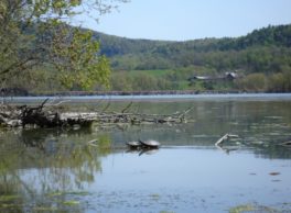
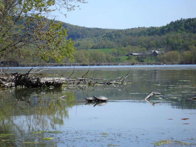
Insider Tip from Paddlers Cathy Frank & Margaret Holden: “South Bay is turtle world. Big ones, small ones, colorful ones, plain ones–all line up on logs and ledges as if waiting for some grand event. Quite, shallow water protected from wind, and a good layer of mud on the bottom for winter protection, make this ideal turtle habitat.”
Other Notes: Water chestnut and milfoil fill many of the bays along this segment and can make paddling along the shore near impossible. Wave driven waves are not an issue, but the waves caused by passing motor boats are significant because boats generally do not slow down for paddlers. While surrounding wetlands absorb the large waves from the power boats, you do need to stay closer to the shore when a boat is passing. In the narrower sections of this passage, where rocks and in some cases walls line the waterway, those waves reverberate off the walls and come back at the paddler for a second round. In those cases, staying too close to the shore is a problem. In other words, be careful and aware of boats.
Activities: 0 hours
Driving: 29 min/11.4 mi
Duration: 1 day
Start at Whitehall Marina
Go south on Main St toward Bellamy St
0.18 mi – 00:01:17
Turn right on Clinton St
0.11 mi – 00:00:21
Turn left on Broadway (RT-22)
0.10 mi – 00:00:16
Turn right on Saunders St
0.02 mi – 00:00:04
Arrive at Whitehall, on the left
Depart Whitehall
Go back east on Saunders St
0.02 mi – 00:00:05
Turn left on Broadway (RT-22)
0.10 mi – 00:00:16
Turn right on Clinton St
0.11 mi – 00:00:20
Turn left on Main St
0.38 mi – 00:02:40
Arrive at The Elbow, on the right
Depart The Elbow
Go back south on Main St
0.38 mi – 00:03:03
Turn right on Clinton St
0.11 mi – 00:00:21
Turn right on RT-22 (Lakes To Locks Psge)
0.70 mi – 00:00:57
Make sharp right on North St
0.12 mi – 00:00:57
Turn right on Northeast St
0.05 mi – 00:00:34
Continue on Railroad Ave
0.24 mi – 00:01:47
Arrive at War of 1812 Mooring Site, on the right
Depart War of 1812 Mooring Site
Go back southwest on Railroad Ave (Elbo St)
0.24 mi – 00:02:07
Continue on Northeast St
0.05 mi – 00:00:34
Turn left on North St
0.12 mi – 00:00:57
Turn right on RT-22 (Lakes To Locks Psge)
1.45 mi – 00:01:39
Turn right and immediately turn right on CR-7A
0.13 mi – 00:00:18
Arrive at South Bay Pier, on the left
Depart South Bay Pier
Go back west on CR-7A (County Route 7A)
0.10 mi – 00:00:14
Turn left and immediately turn left on RT-22
0.41 mi – 00:00:29
Turn left on CR-7A (County Route 7A)
0.16 mi – 00:01:10
Arrive at South Bay, on the right
Depart South Bay
Go back southeast on CR-7A (County Route 7A)
0.16 mi – 00:01:01
Turn right on RT-22 (Lakes To Locks Psge)
5.21 mi – 00:05:49
Turn right on Clemons Center Rd
0.04 mi – 00:00:06
Turn left on Lake Rd
0.67 mi – 00:01:37
Finish at Chubbs Dock Landing, on the left