
Andebit et beaqui corendit, ut quostes esciendion re dit ad et prae parion es quia quas alibus sam, omnim faciden ducipidiat arum autem nobis enis es voat

Great Sacandaga Lake Bicycle Loop
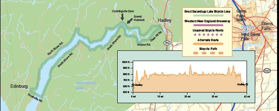
Away from traffic, always near water and no great big hills is what this ride has to offer in a chance to circle the Eastern end of the Great Sacandaga Lake. Quaint and pristine, the area is currently a unique setting for a multitude of recreational activities of which bicycling is only one. What cannot be seen is the great history that existed in the valley prior to the building of the Conklingville Dam in
the 1920s. Originally the home of Mohawk Indians the area was settled by the English in the 1700s. The beauty of the valley generated development that made the area a popular resort area up until the early 1920s. The spring floods cause severe damage each year which eventually resulted in the
building of the dam. This ride only covers the eastern end of the lake to provide a comfortable trip for the average bicyclist. A trip around the entire lake is approximately 140 miles. It is hoped that
This ride only covers the eastern end of the lake to provide a comfortable trip for the average bicyclist. A trip around the entire lake is approximately 140 miles. It is hoped that
by experiencing this limited part of the lake that other areas will be explored as one wishes. This ride can also be shortened by crossing at the Conklingville Dam and returning to Hadley.
Immediately after leaving the business area of Hadley the route crosses the Sacandaga River on a lovely arch bridge and turns right and up on Dean Mt. Road. Do not be discouraged. This short climb on a dirt road is tough but limited and the only unpaved part of the route. The only other major hill is on the Norrisville Rd. where the route crosses the lake and goes to Edinburg. Services are limited on the route and food is available only at the eastern and western ends of the route.
Start at the Town Hall in Hadley which is just north of the town of Lake Luzerne on Rt. 9N.
0.0 Proceed south on Old Corinth Rd. at the corner with Rockwell St.
0.2 Cross Sacandaga River on the Hadley Bow Bridge.
0.3 R onto Dean Mountain Rd.
0.3 Pavement stops for 0.4 miles – this is a tough climb – the rest of the trip is worth it.
2.3 BR onto Antone Mountain Rd.
2.8 BL onto South Shore Rd (CR7).
6.2 S – Pass Conklingville Dam continuing on Kathan Rd. (CR7) – this is a place to make a short ride by turning and crossing the dam.
19.6 Store.
19.9 R onto Northville Rd. crossing the lake.
21.4 R onto Sinclair Rd. (CR4).
21.4 S into Edinburg – store and diner.
36.5 S – Pass Conklingville Dam – road becomes North Shore Rd. – Interpretive sign.
37.2 Enter town of Hadley.
37.7 Scenic Overlook.
41.6 Road becomes Rockwell St.
42.0 End
Location
Downloads
NearBy

Lake Champlain Bikeways
802-652-BIKE
c/o Local Motion Trailside Center
1 Steele St. #103
Burlington, NY 05401 US
[email protected]


