
Andebit et beaqui corendit, ut quostes esciendion re dit ad et prae parion es quia quas alibus sam, omnim faciden ducipidiat arum autem nobis enis es voat

Lake Champlain Blueway Trail
Explore the Lake Champlain shoreline through the Lake Champlain Blueway Trail. It is a recreational water path with information on points of interest. Primarily for use by paddlers, it can, however, be used by all boaters, even those who travel along the frozen lake in winter! Points of interest include launch sites, marinas, historic sites, natural areas, wildlife viewing sites, museums, campgrounds, parks, and other recreational activities.
The trail has been organized into a series of 16 segments, each intended to be enjoyed as separate day trips:
Rouses Point to the Great Chazy River: Start in the Village of Rouses Point and continue down and around the historic Point au Fer. From here, paddlers have an uninterrupted view down the lake as you follow a marshy shore. At Kings Bay Wildlife Management Area, paddlers will have the opportunity to observe the abundant wildlife up to the mouth of the Great Chazy River.
Great Chazy River to Point au Roche: Along this shallow and marshy shoreline, paddlers will pass historic Chazy Landing and have access to Montys Bay Wildlife Management Area for wildlife viewing, hunting, and fishing.
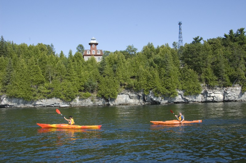
Point au Roche to Cumberland Head: Paddlers will enjoy the view of the Point Au Roche Lighthouse, a series of beautiful bays, and access to Point Au Roche State Park with a sandy beach, swimming area, and trail network.
Port Kent to Cumberland Bay: This route begins in Port Kent and continues through two different wildlife management areas, both of which offer excellent wetland wildlife viewing opportunities. This segment is “hallowed water,” the site of several naval battles that were fought to control Lake Champlain over 200 years ago. The route ends at the Plattsburgh City Beach, which is adjacent to Cumberland Bay State Park. Recommended to paddle from south to north.
Valcour and Crab Islands: The Valcour and Crab islands trail guides you around one of Lake Champlain’s largest and most historic islands and its smaller neighbor. Explore the many bays and points along the islands. You can also learn about the best places to explore the islands on foot at this PassagePort. Valcour has a number of primitive campsites.
Port Kent to Willsboro: Begin this paddle in the hamlet of Port Kent, explore Schuyler Island, and continues south to the historic hamlet of Port Douglas, where you will find a sandy beach and swimming area before continuing on to Willsboro Bay.
Willsboro Bay to the Four Brothers Islands: This segment begins in the picturesque Willsboro Bay and takes paddlers around Willsboro Point, out to the Four Brothers Islands with unparalleled bird watching opportunities, ending near the mouth of the beautiful Boquet River.
Boquet River: A paddle up this river is a trip through history, ending at the hamlet of Willsboro, where shopping, dining, and other recreational opportunities are plentiful.
Westport (Split Rock) to Essex: Explore the section of the lake known as “The Narrows,” named for the obvious reason that this is the narrowest part of the lake, rich in history and natural beauty. Paddlers can pick through the many harbors and points along this shoreline, including the unique “Palisades of Lake Champlain,” a geological masterpiece of sheer cliffs ornamented with waterfalls and wildlife. This segment ends in the hamlet of Essex, with shopping, dining, and parks to enjoy. It is recommended that this segment be completed south to north.
Port Henry to Westport: This route begins in the Village of Port Henry and passes a number of iron-history sites along the shoreline, including a once-industrious brook and a small island believed to be where a famous Jesuit missionary was tortured while held captive by the Mohawks. The route ends in the town of Westport, where paddlers have access to shopping, dining, parks, and a beach and swimming area. It is recommended that this segment be completed south to north.
Crown Point and Port Henry: Paddlers can put in at Crown Point State Historic Site, the location of two separate forts under different sovereigns. Nearby are campgrounds, a historic lighthouse and pier, boat launch, and museum. The route continues along Bulwagga Bay, and then onward to the village of Port Henry with shopping and dining, parks, beaches, campgrounds, and a museum that showcases the town’s mining and iron ore heritage.
Crown Point to Monitor Bay: This short segment consists of marshes, resulting in a vibrant and diverse habitat of plants and animals. Paddlers can explore Putts Creek Wildlife Management Area before reaching the Town of Crown Point’s Monitor Bay Park and Marina. It is a short walk from here to a bank, stores, and restaurants.
Monitor Bay to Ticonderoga: Explore a narrow and marshy shoreline of the lake that is almost river-like. Wildlife is abundant here, especially birds and waterfowl.
Ticonderoga and La Chute River: Paddlers get a terrific view of Fort Ticonderoga and its impressive grounds on this segment. The strategic importance of this fort was its location at the mouth of La Chute River, which is the waterway that connects Lake Champlain to Lake George. From Fort Ticonderoga, it is smooth water to downtown Ticonderoga.
Ticonderoga to Chubbs Dock: Paddlers will start near Fort Ticonderoga, passing through the narrowest point in the lake. The southern part of Lake Champlain has been referred to as the “drowned lands” because it is surround by wetlands, rich with wildlife.
Whitehall to South Bay (Chubbs Dock): This segment begins in historic Whitehall, the birthplace of the American Navy, and brings paddlers through the waters that became a murky grave for a number of Revolutionary War ships. The trail also explores South Bay, which offers paddlers ample wildlife viewing opportunities. It is recommended that this segment be completed south to north. Extensive advice about exploring and paddling Lake Champlain can be found in these two books:
A Kayaker’s Guide to Lake Champlain: Exploring the New York, Vermont, and Quebec Shores by Catherine Frank and Margaret Holden (Black Dome Press, 2009). This book is a great resource for learning about the many opportunities for touring all of Lake Champlain by paddle craft.
A Paddler’s Guide to the Champlain Valley: Exploring the Rivers, Creeks, Wetlands and Ponds by Margaret Holden and Catherine Frank (Black Dome Press, 2016). The book covers 42 paddles on Lake Champlain’s rivers, wetlands, and wildlife refuges, discussing not only the logistics of each trip, but also the ecology, geology, history, and plants & wildlife of the region.
NearBy
518-597-9660


