
Andebit et beaqui corendit, ut quostes esciendion re dit ad et prae parion es quia quas alibus sam, omnim faciden ducipidiat arum autem nobis enis es voat

Saratoga Battlefield Bicycle Route
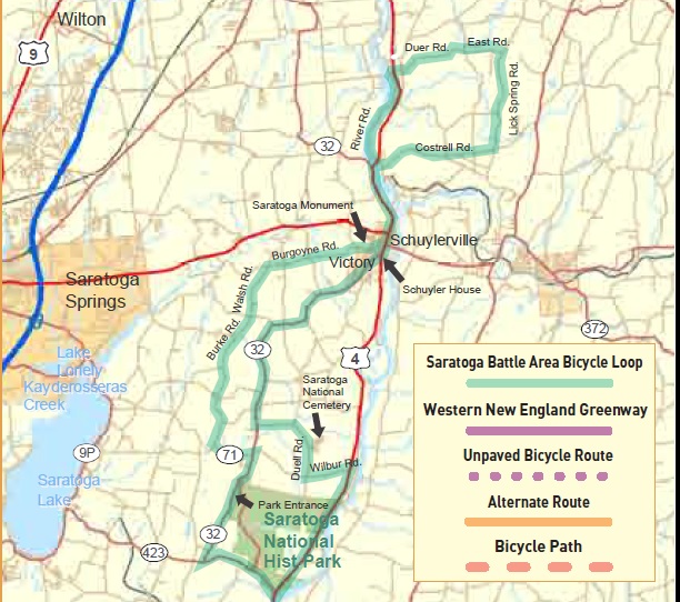
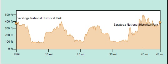
The significance of the Battle of Saratoga cannot beappreciated without a tour of the battlefield itself appreciated without a tour of the battlefield itself. The National Park Service has an excellent map, available at the park office, that guides one on a 10 mile loop of well interpreted sites in the battlefield itself. That is why those directions are not included here. This tour goes around the park, past several historic sites in Schuylerville and makes a short loop into the countryside before returning to Schuylerville along the Hudson River and then the park.
The first stop after traveling along the river is the Saratoga National Cemetery which is a relatively new national cemetery. The grounds are impressive and a respectful ride through provides the opportunity to reflect on the fact that the values fought for years ago are still being defended today. The Schuyler House is a short distance to the right on Rt. 4 when entering Schuylerville and a visit will return you to the area’s historical past. North of Schuylerville is a loop through the country that offers relaxed riding with little traffic. The directions provided are a guide. Explore the other roads as time permits, most are great for bicycle touring and you won’t get lost. Returning to Schuylerville the route parallels the Hudson River back to the bridge. As of this writing road construction was in process with various projects that would allow even better access to river views. Follow the directions or explore a little around the canal lock.
Leaving Schuylerville, the Saratoga Monument is on you left, on Burgoyne Road, and is open seasonally to the public. Situated on a high bluff on the grounds of Burgoyne’s last camp the monument offers wonderful views of the Hudson River Valley prior to the return ride to the Saratoga Battlefield.
Start at the Lower Battlefield Parking Lot
0.0 L onto Rt. 32.
2.5 L onto Rt. 423.
4.7 L onto Rt. 4 (Bike Route 9).
7.1 S onto Park Entrance on left.
8.5 L onto Wilbur Rd. – 150 ft. climb.
9.6 R onto Duell Rd.
10.0 Entrance to Saratoga National Cemetery.
10.0 R onto Duell Rd. returning to Wilbur Rd. when leaving the cemetery.
12.0 R onto Rt. 32.
18.3 L onto Rt. 4. Schuyler House is 0.1 miles to the right on Rt. 4.
18.4 S – A left turn onto Burgoyne Rd. Will allow a shorter 30 mile ride.
20.6 R – Cross the Hudson River on Rt. 4.
20.8 R onto CR 113. Clarks Mill Rd.
21.0 L onto Thomson Rd. There is a sign with an arrow to the zoo.
22.8 S at Cross Rd. onto Coltrell Rd. (CR 77).
24.0 L onto Lick Spring Rd.
26.6 L onto East Rd. which becomes Duer Rd.
29.5 L onto Rt. 4.
29.6 R onto Lock Rd.
29.7 L onto Ft. Miller Rd.
30.4 L onto Green St.
30.5 R onto Rt. 4.
32.4 R onto Rt. 4 crossing Hudson River.
34.8 R onto Burgoyne Rd. Saratoga Monument is on the left.
35.4 BL – Staying on Burgoyne Rd.
37.7 L onto Walsh Rd.
39.0 S – Cross CR 68 onto Burke Rd.
40.6 S onto Mabb Rd. which becomes Spock Hollow Rd.
41.4 S – Pass Ruckytucks Rd. onto CR 67.
42.0 R onto Spocks Hollow Rd.
43.0 L onto CR 71.
43.7 R onto Rt. 32.
44.7 L onto Battlefield entrance.
Location
Downloads
NearBy
Lake Champlain Bikeways
802-652-BIKE
c/o Local Motion Trailside Center
1 Steele St. #103
Burlington, NY 05401 US
[email protected]


