
Andebit et beaqui corendit, ut quostes esciendion re dit ad et prae parion es quia quas alibus sam, omnim faciden ducipidiat arum autem nobis enis es voat

Town, Lake, and Battlefield Bicycle Loop
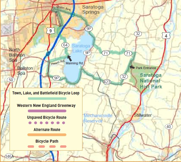
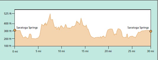
Saratoga as a word covers all three and all three are visited on this tour. The City of Saratoga Springs is noted for hot springs, the Saratoga Performing Arts Center, the historic Gideon Putnam Hotel and horse racing. Starting near the center of town the route leads through some of the many stable areas before passing Yaddo Gardens, an art colony that is open to the public. After a short excursion around part of Saratoga Lake and a climb away from the lake the route traverses farmland until arriving at the entrance to the Saratoga National Historical Park.
The significance of the Battle of Saratoga cannot be appreciated without a tour of the battlefield itself. The National Park Service has an excellent map, available at the park office, which guides one on a 10 mile loop of well interpreted sites in the battlefield itself. That is why those directions are not included here. Another tour in this series goes around the park, past several historic sites in Schuylerville and makes a short loop into the countryside before returning to Schuylerville along the
Hudson River and then the park. Combining the two tours will provide even the most enthusiastic bicyclist with a full day of riding enjoyment.
The return to Saratoga Springs continues around the southern part of Saratoga Lake before re-entering the city. The race track complex is approached with the entrance to the casino on the left and many stables and race tracks within view. Bicyclists should be very cautious when horses are crossing nearby and careful not to alarm the horses or their handlers. Saratoga Springs other attractions can easily be visited by bicycle but the town is an active community and motor vehicle
traffic can be heavy.
Start at east side of Congress Park, corner of Circular St. and Union Ave. (Rt. 50)
0.0 Go east on Union Ave., Bike route A. Pass Saratoga Race Track.
1.5 Yaddo Gardens on the right.
1.6 Cross I-87.
2.5 BR – Stay on Rt. 9P.
3.7 Cross Sarotoga Lake onto Saratoga Lake Rd. (Rt. 9P).
5.3 L onto Cedar Bluff Ct. (CR 71).
9.6 R onto Rt. 32.
10.4 Saratoga National Historical Park is on the left.
10.4 S onto Rt. 32.
12.6 R onto Rt. 423.
16.5 L onto Rt. 9P.
20.7 R onto Rt. 9.
21.9 R onto CR 63, Hearn Rd., which becomes Manning Rd.
24.5 S onto CR 64.
25.9 R – Cross I-87 and turn right staying on CR 64.
26.9 Cross CR 22 and road becomes Nelson Ave. Pass tracks, casino and stables.
28.1 L onto Lincoln Ave. at the light.
28.4 R onto Park Place at the five corners light.
28.7 R onto Circular St. (Rt. 50).
28.8 End
Location
Downloads
NearBy
Lake Champlain Bikeways
802-652-BIKE
c/o Local Motion Trailside Center
1 Steele St. #103
Burlington, NY 05401 US
[email protected]


