
Andebit et beaqui corendit, ut quostes esciendion re dit ad et prae parion es quia quas alibus sam, omnim faciden ducipidiat arum autem nobis enis es voat

Two States Bicycle Loop
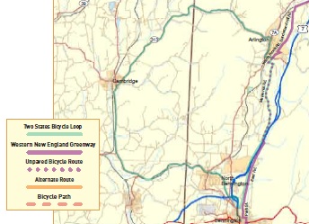
Starting in Bennington, original home of the Green Mountain Boys, this ride offers the benefits of the
complete facilities of a large town, the intimacy of small towns and miles of country riding in between. The Bennington Battle Monument is an obvious site but the real history of the area is best investigated at the Bennington Museum before or after the ride. The town is also home to Bennington College, known for its strong and unique liberal arts program, and has three covered bridges in the area. Named by the Governor of New Hampshire for himself when the town was founded the area was claimed by both New York and New Hampshire. This dispute resulted in neither state having control and the beginning of Vermont.
Leaving Bennington the route quickly becomes country with gentle rolling terrain along small rivers and streams famous for fishing. Entering New York the route goes through North Hoosick, near Eagle Bridge and into Cambridge, the last places for food for a long way. Back in Vermont the route follows the Batten Kill, fishing mecca, into Arlington with its lovely and historic churches, cemetery and inn. Wonderful at any time of the year, Arlington’s great trees are a special treat in the fall.
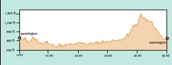
After leaving Arlington, mile point 36.8, the route begins an 800 ft. climb in about 8 miles on back roads before a nice long decent back into Bennington. If one is really tired at this point you can continue south on Rt. 7A all the way to Bennington. There is still a long climb up through Shaftsbury but it is only about 400 ft. While Rt. 7A has some traffic the majority of the north-south traffic is on Rt. 7 which is a limited access highway and bicycles are not allowed.
Start at Southwestern Vermont Medical Center – Monument Ave and Hospital Drive, Bennington, VT
0.0 R – Leave parking lot onto Monument Ave.
0.8 BL on Parkway to bypass a ONE WAY section of Monument Ave. ahead.
1.0 BL onto Monument Ave.
1.2 L at Bennington Monument.
1.4 R onto Fairview St.
1.9 R onto Silk Rd.
3.4 L onto Rt. 67A.
4.5 R onto Water St. (Rt. 67A) – Henry Covered Bridge is 0.4 miles to the left on River Rd.
7.7 Cross State Line.
11.8 S at North Hooskck continue on Rt. 22.
14.2 Continue on Rt. 22.
19.3 R onto Rt. 313 (Maple Ave.) in Cambridge.
28.1 Cross State Line.
35.1 R onto Rt. 7A in Arlington.
36.8 L onto Cemetery Rd.
37.2 R onto Warm Brook Rd.
37.3 L onto Maple Hill Rd.
37.6 R onto Maple Hill Rd. which becomes East Rd.
43.6 Cross under Rt. 7.
48.9 Road becomes Park St. in Bennington.
49.6 R onto County St.
50.1 L onto Benmont Ave.
50.3 Cross Main St. (Rt. 9) onto Dewey St.
51.4 R onto Monument Ave.
51.7 R onto Hospital Dr.
Location
Downloads
Lake Champlain Bikeways
802-652-BIKE
c/o Local Motion Trailside Center
1 Steele St. #103
Burlington, NY 05401 US
[email protected]


