
Andebit et beaqui corendit, ut quostes esciendion re dit ad et prae parion es quia quas alibus sam, omnim faciden ducipidiat arum autem nobis enis es voat

Waterways of War: The French & Indian War
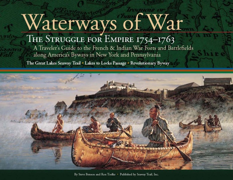
The super-powers of the 18th century — France and Great Britain — contested for empire and the destiny of North America along a strategic triangle of waterways in today’s New York State. The St. Lawrence and Mohawk rivers provided access to the heart of the continent from the Atlantic Ocean. Northsouth, the Hudson River/Lake George/Lake Champlain waterway linked the principal French trading centers in Montreal and Quebec with British centers in Albany, New York City, and the interior.
European kings sought to control the waterways penetrating the North American continent by controlling the waterways Indians had been using for trade and war for millennia. “_x001C_The lakes and rivers are the only outlets, the only open roads in this country,” observed a senior French officer. By the 1730s, after a generation of intensive construction on the frontiers, a ring of forts protected the water gateways of New France: Louisbourg guarded the mouth of the St. Lawrence on the Atlantic Ocean; Niagara, to the west, controlled access to and from the Great Lakes; St Frederic at Crown Point protected the Lake Champlain portal to the south. As frontier tensions erupted into open warfare in the mid-1750s, old forts were strengthened and new, more distant, outposts nearer the enemy were built along these waterways. This was a World War.
Adapted from Waterways of War Introduction written by Nicholas Westbrook Vice Chair, NYS French & Indian War 250th Anniversary Commemoration Commission and Director Emeritus, Fort Ticonderoga Best Times to Go
Late Spring, Summer, or early Fall.
What You Should Know Before You Go
Three New York State Byway routes correspond to the three legs of the New York waterway triangle. Lakes to Locks Passage takes the traveler to key sites along the Albany to Montreal route, the landscape of the PBS documentary Forgotten War: Struggle for North America; the Great Lakes Seaway Trail links Montreal to Lake Ontario, Lake Erie and Western Pennsylvania; and the Revolutionary Byway connects Lake Ontario to Albany. This Byway network is where history in your own backyard dramatically became world history, thrusting the visitor into the heart of the French and Indian War.
Do part of it. Do all of it. Learn. Enjoy the discoveries that await you!
The Mountain Lake PBS documentary Forgotten War: The Struggle for North America, www.forgottenwaronline.org tells the compelling story of the French and Indian War struggle to determine who controls the vast reaches of North America: The French, the British, or Native peoples who have lived here for generations. This website provides additional interviews, classroom lessons, and links to the extensive research done for the documentary.
NYS French and Indian War 250th Anniversary Commemoration planned and organized events to celebrate and recognize New York State’s role in the French and Indian War. Their contributions to the development of the interpretive materials and documentary Forgotten War is greatly appreciated.
What About this Experience is Distinctive or Authentic to the Character of the Region?
This is a story about nation-building in the New World, and the primary dispute is over the frontier wilderness and control of the waterways of New York.
Additional Notes
Click here for a Googlemap-based itinerary to Waterways of War, introducing the traveler to a multi-cultural story about the birth of nations: the United States, Canada, Britain, France, and numerous Native nations. Click on the “read more…” hyperlink at the bottom of each point of interest for the full page spreads as they appear in the Waterways of War guidebook. Fees (if any)
Contact the individual sites for individual site fees.
Location
Downloads
Andrew Alberti - Lakes to Locks Passage
518-597-9660
US
[email protected]


